The project has a history that goes back to the late seventies, when among other "visionary" projects, a new "Television City" was proposed, eventually being touted by Donald Trump to contain the tallest building in Manhattan, surpassing the Empire State and the World Trade Towers. Its name evoked its proposed status as the updated version of Rockefeller Center/Radio City - the next generation of tenant-centered promotion of real estate. ABC and CBS had production facilities nearby - still do - and there was seen to be a need for studio space that overlapped with grand plans and the availablity of underexploited property that could be turned profitable by bridging over the existing rail lines.
Soon things changed, and the TV industry was out and "Trump City" remained - now residential and looking for zoning revisions to allow density beyond what had ever before been considered. With some stops and starts, the buildings have been under construction for what seems to be forever now, with very little fanfare or its opposite. For the Upper West Side of the last decade, lack of interest in and vocal reaction to neighborhood transforming development is unusual. (Nearby, the riverfront esplanade has as a feature, the twisted remains of a burned out waterfront warehouse - it was kept as a relic, well spoken for by some UWS supporters, while others wonder and search for words to explain it to tourists.)
Construction is still underway, and it may be unfair to assess the project until it has mellowed in a bit, but what is already there makes a clear statement - or a few not-so-clear ones.

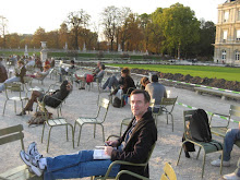
The project looms, for the most part, over the riverfront esplanade. The parks and fields at the promenade level are well used - the Parks department schedules use of the fields, and local residents of all ages are out on the walks and benches in even questionable weather. If you don't look up and inward, the leviathans disappear from your presence. Occasionally, they are well screened by well-placed trees lining the walk.
The "Miller Highway" is maybe a stronger player, and one that defines and undermines the projects relationship to the river and the promenade. The highway's ground level is currently occupied, between the parks and the buildings above, by an extension of the bikepath (bikes only, at Lance Armstrong speed, pedestrians beware), and a drive for contractors trucks working at both the south and north ends (the trucks are less frequent and more careful).
And then a DMZ of green - a huge sloping lawn, seeded and reseeded, crossed only by a ramp and a precipitous stair - leans up to the occupied terrace above. There was a plan to remove the highway to an underground tunnel and landscape the slope into something plausible, but the private side balked, and the civic side didn't step in. Yet, I guess. It is so surreal, it has to inspire someone to do something someday - maybe it will need to be income-generating.

Once up on top, the confounding highway is at eye-level to one side, and the cliff of buildings rises, seemingly uninterrupted to the other. The buildings are big: they are of differing designs, but the moves are all similar in scale, windows and setbacks move in similar ways, that they create a wall from one end to the other. The street - sorry, the Boulevard - is hard to inhabit. It doesn't favor the river views, even after the highway is enough out of the way, or favor the enormous wall of buildings, as at some parts of Riverside Drive, where the undulation of the street wall takes over as the river views are lost by trees in the park.
The buildings are hard to assess (partial full disclosure: I worked on some similarly sized residential buildings). You can see the formula for their development in 3-D. You can even see the floor-to-floor heights go up as you go south to the later buildings. We now need ten-foot clear ceilings. The extent of detailing is limited not only by the limits of economical production of cast-concrete details and brick, but by the proportion of solid to void. We now need BIG windows. Floor-to-ceiling glass. But still balance the solid (cheaper) to void (expensive). Finesse is tough in this formula.
Added to the increasing height in the later buildings, is the change to Low-E glass that gives the newer buildings a glassy-eyed ghostiness. They are even less "there" than the older buildings. We'll steer away from any opening for a "green" discussion here.
The street grid is not complete - the link to 72nd Street to the north is almost there, the development to the south is still a few buildings short, and the street pattern's resolution may make the loneliness go away. (Today, the doorman for the northernmost building had to run down to the next corner to get his tenant a cab. They should let him wear something more athletic than his full regalia. At least the cabby gave him a ride back.)
The side streets are where we see the scale of the new collide with the existing. The attempts at contextualism here are more clearly delineated than at that last celebrated and just as often critiqued urban intervention - Battery Park City. There the context is not Right There. The guidelines at BPC are meant to recall the UWS at its best, and they work better there because the project makes its own context. And the knitting into the grid is less of an issue, and the connection to the river is more direct. And back that short time ago, the developer market did not have the same drivers - some well-tested architects were entrusted with the buildings designs, and the results are more subtle.

The inner north-south street "Freedom Av", has a retail side and a blank side where it meets the existing garage of one of the Lincoln Terrace projects. A semi-circular mini-plaza in the west side has a "friendly" market on one corner that has chosen to cover all of its windows with posters. Service retail occupies some other storefronts, and does have the feel of its BPC counterparts. Waiting.
It probably is a great place to live for its tenants. Views, service, parking in the building, adjacent to a great neighborhood. But not a neighborhood, yet. And not a place.
It may be a little easy to critique something like this development. It took a great deal of effort and risk to get it done. It is always amazing when something this large "happens". But some of the effort may never attain the desired effect. The tie-in to the grid doesn't yet look promising, and it may always be hampered by the change of scale of the buildings and their details. we are not on the Upper West Side any more. And until it is a through route to connect with the now complete park/esplanade, it will remain a land-locked island. If the highway never comes down, the DMZ between it and the terrace needs to be integrated and strong.
This project shares some of the favorable isolation of some other New York enclaves - Battery Park, as already mentioned, Tudor City, and Sutton Place and East End Avenue. But again, the scale of these buildings mitigates against its even being considered an enclave. These buildings loom above the neighborhood and the park, their bulk not helped enough by an occasional "tower". And strangely, it is that problem that needs to be addressed by more inclusion where they meet the ground - some more "events" that will help them achieve some groundedness.
Again, criticism may be easy. But the city has been on the brink of some urban-scale projects for the intevening decade - the new World Trade Center and Hudson Yards (again partial disclosure: I was on one of the Hudson Yards design teams) and there is need for caution and deliberative thought. Good intentions and good economics are never enough, that has become accepted, and proven.

I've just finished reading Daniel Okrent's "Great Fortune" about the development of Rockefeller Center. It was a very different time. The economy was bad then too, but the source of funds was steady. The return on the dollar was important, and agressive measures used to get the work done and to get tenants. The effort was enormous, the players and the parts varied to extreme. The actual design and build schedule was quite compact, but it came after years of preparation and acquisition, infighting and vision-making. But in the end, the uses changed, the participants changed, but the original goal of place-making remained. In fact the "place", the central plaza survived decades of dreaming and doing. And it is a "place", one of the best. Not a "Place".